Bloody
Skillet Connector Notice:
Department of Conservation and Natural Resources
has started to do some work on the connector
at the township road end and will be working
towards the Bloody Skillet ATV area. Please
be alert as you may encounter, heavy equipment
and vehicles on the connector trail as they
travel it from the Texas Eastern Gas Line
to Bloody Skillet. There has also been some
trail markers and signs removed along the
connector and there is more and more evidence
of atv's traveling off of the connector trail
corridor and into areas not open to ATV's.
Please report anyone removing signs and or
not staying on the trail.
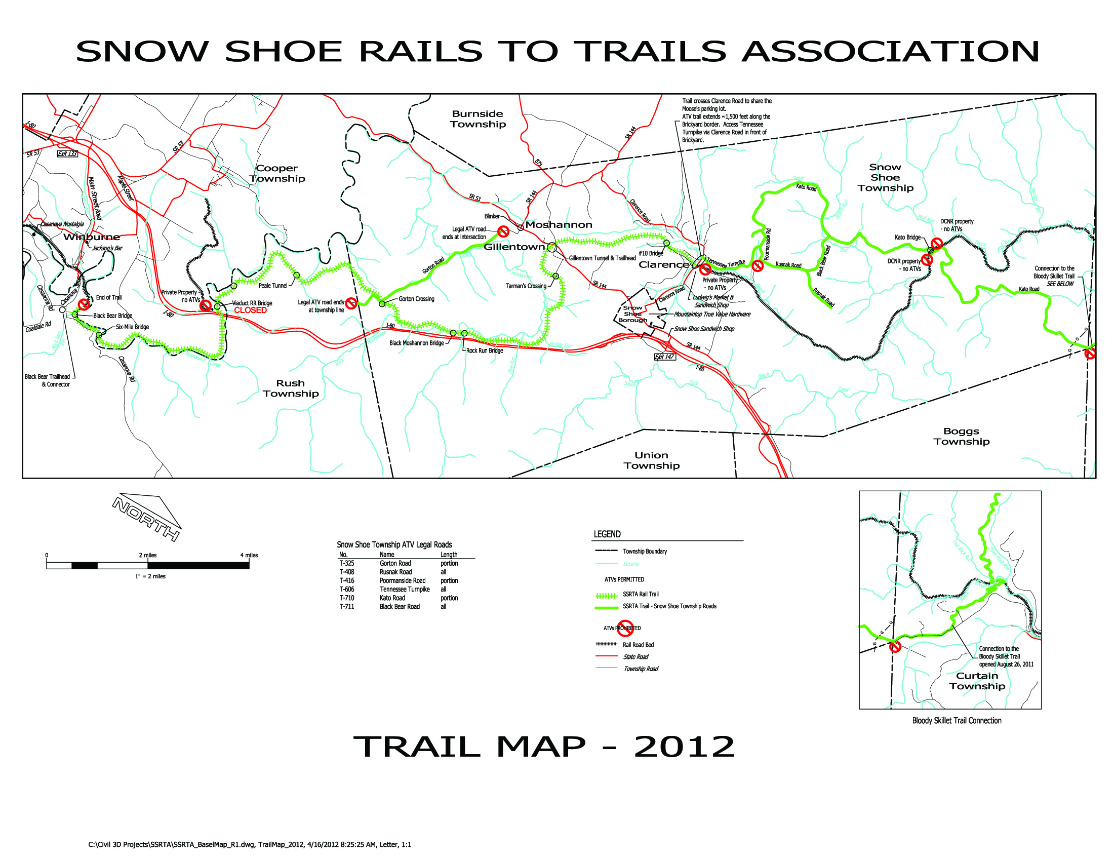
The Snow Shoe Rails to Trails now connects
to the Bloody Skillet ATV riding area in Centre
County via a 6 1/2 mile connector trail. This
connector can be found at the Clarence side
of the rails to trails.
The Bloody Skillet ATV riding area consists
of 37 trail miles (Phase 1 & 2) and is
accessed from SR 144 approximately 18 1/2
miles north of Snow Shoe. Turn right onto
DeHaas Road and travel 5 miles south to the
Northern Terminus Trailhead. Registered Class
II ATV's are permitted on this trail that
are less than 58" in width and less than
1,200 pounds.
Bloody Skillet is open during the summer and
winter seasons. The summer season runs from
the Friday before Memorial Day through the
last full weekend in September. The winter
season runs from the day following the last
day of the regular or extended antlerless
deer season as established by the Game Commision
through the following April 1. There are some
trails that remain closed until after the
late muzzleloader season, please check with
the individual forest district to see when
the trails will open for the winter season.
Directions To
Gillentown Trailhead
Get off Interstate 80 at Snow Shoe. Take route
144 north approximately 1-1/2 miles to a 4
way stop. There will be two churches on the
left. Proceed straight ahead on north 144
another 2 miles. Seprish Recycling will be
on your left at the top of a hill. Start slowing
down and proceed another 200 yards to the
bottom of the hill. Turn left at Gillentown
Trailhead sign. Go approximately 300 yards
back the road to several acres of parking.
The trail is adjacent to the parking area.
Directions To Black
Bear Trailhead
Take Interstate 80 to Kylertown Exit. Turn
north onto Route 53. Go about 1/3 mile and
turn right onto Main Street (This is the very
first road past the east bound interstate
80 exit). Stay on Main Street (after about
2 miles you will see the fire hall and Jackson's
Bar on left). Continue about 1/2 mile and
you will pass the old Avondale Hotel on your
left and the road makes an extreme left hand
turn with a park on your right. The road crosses
over a bridge that spans the Red Moshannon/Centre
County Line. Continue up a hill and the Black
Bear Nursery will be on your left and a stop
sign just past the nursery. This concludes
about 3.7 miles from Route 53 to the Trailhead.
Turn right at stop sign and go about 200 feet
and turn left into the Entrance to the Black
Bear Trailhead. There is a large sign on the
left of the entrance "Black Bear Trailhead"
and a large rock on the right side of the
entrance with a bear inscribed on it. Proceed
to the back of the parking area. (No camping
overnight at The Black Bear Trailhead).
From
Route 220, take Steel Hollow Road to Julian
Pike, turn left towards Black Moshannon State
Park. At Route 504 intersection turn left
(towards Philipsburg). Go 0.1 miles across
the bridge, turn right onto Casanova Road
(towards Winburne/Kylertown) for 5.8 miles
to trailhead on the right.
From
the Philipsburg area, take Route 504 towards
Black Moshannon, turning left onto Hanna Furnace
Road (a well maintained gravel road). Go 3
miles turning left onto a paved road (Casanova
Road) then 0.6 miles to trailhead on left.
Another
option from Philipsburg is to take Coaldale
Road to the Casanova Road turning right and
going 0.4 mile to the trailhead on the right.
|